National Vineyard Scan
About the report
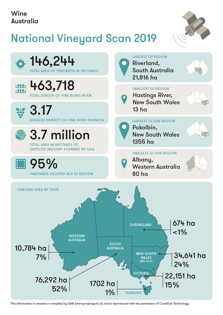
The National Vineyard Scan is part of a project funded by Wine Australia to geolocate all winegrape vineyards in Australia, using a computer algorithm to scan aerial imagery and detect vineyards without human intervention. The project has been undertaken by Consilium Technology on behalf of Wine Australia and will be repeated for three years from 2018-2020.
The report provides total vineyard area by GI for all GI designations in Australia, as well as total vinerow length and average vinerow length per hectare.
Report summary
The National Vineyard Scan 2019 found the total area of winegrape vineyards in Australia to be 146,244 hectares. This compares with 146,128 hectares reported in the first National Vineyard Scan 2018 and 135,133 hectares reported by the ABS in the last vineyard survey conducted in 2014. The small changes in vineyard area detected in the 2019 scan are primarily attributable to improvements in the accuracy of the GAIA algorithm, in particular the removal of many ‘false positives’ (non-vineyards mistakenly identified as vineyards) from the first scan.
The increase of 11,000 hectares nationally in four years is less than 2% average annual growth rate, indicating only very moderate increases in plantings over that timeframe.
The total vinerow length measured in the 2018 National Vineyard Scan was 463,718 km, representing an overall average across all vineyards of 3.17 km/ha. The state with the highest vine density (vinerows per hectare) was Tasmania, and the lowest were New South Wales and Queensland. This dimension was not re-measured in the 2019 scan.
Vineyard location maps
Maps of the major GI regions showing vineyard locations can be found in the state vintage reports for 2019. Maps for smaller regions are available on request.

Source
The National Vineyard Scan is part of a major project called Vinsites being undertaken by Wine Australia to develop a foundation data set of Australia’s winegrape vineyards, including area, location and varieties.
The project fits under Strategy 4 of Wine Australia’s strategic plan: Improving resource management and sustainability.
More information on the National Vineyard Scan project.
More information on the Vinsites project
To visualise and explore the vineyard scan data, please visit the Wine Geographical Indications dashboard.